In 2009-10 five teams of architects, landscape architects, and other professionals were invited to take part in a workshop at PS 1, organized by MoMA and Barry Bergdoll, then Head of the Architecture and Design Department, to address the problem of global warming and its impact on lower Manhattan. This was three years before Hurricane Sandy battered Manhattan in October 2012.
City officials from various agencies including the Office of Emergency Management, Department of City Planning, and various New York State agencies, along with climate scientists and the public, were invited to attend these meetings. The workshop led to five different interventions for the treatment of the Upper Harbor of New York and New Jersey by the design teams and an exhibition at MoMA in 2010. The Drawings, Prints, and Graphic Design Department has recently added one of these projects to document in the permanent collection the proposal of National Design Award winners Architectural Research Office (ARO) in collaboration with Susannah C. Drake of delandstudio. Drake’s contribution came out of an earlier solution she designed in 2008 for cleaning up the Gowanus Canal with what she termed "Sponge Park" – strategically located planted areas absorb and filter storm water runoff before it enters the Canal. The ARO/delandstudio proposal, called "A New Urban Ground," transforms lower Manhattan through a series of constructed wetlands along the coastline and absorptive open-mesh concrete streets into a green and eco-friendly transitional field that will allow Manhattan to survive by interacting with the rising sea levels that are predicted as a result of climate change. These systems will provide a buffer against rising water and restore the natural dynamic of the water and the landmass.
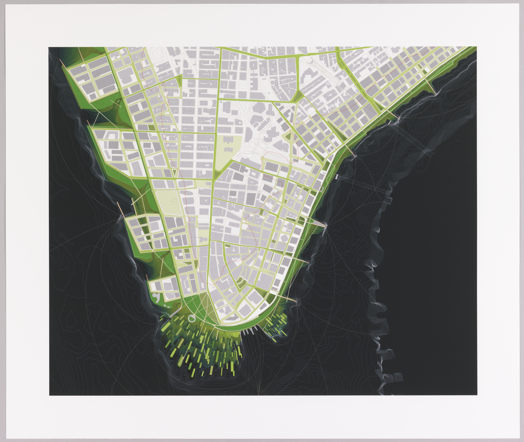
Five digital renderings were acquired for the collection. This rendering is a schematic view of lower Manhattan showing the extent of the proposal connecting land and water. The proposal adds two miles of shoreline to Manhattan and shows the levels of interventions in different colors of green. The light green areas are salt water marshes, the medium green areas are freshwater wetlands, and the dark green areas are parks. An outer dotted line shows high tide based on a projected sea level rise of six feet. The inner dotted line shows the area that would be flooded by a 24-foot storm surge from a level 2 hurricane. Another rendering (2013-52-2) imagines a perspective view of lower Manhattan to illustrate the new ecological inter-connectedness of the Park areas the salt and freshwater marshes, and a marina.


Two additional views, seen above, illustrate lower Broadway (2013-52-3) and Hanover Square (2013-52-4). These images show the porous, layered concrete streets that will absorb and distribute the flood waters in different levels. They also illustrate two kinds of underground vaults. One is for dry utilities, such as electricity and telecommunications wiring; the other is for wet utilities – water, gas, and sewers.
Finally, there is a view of the eastern shore of lower Manhattan (2013-52-5) seen below, illustrating a series of raised walkways connecting the man-made estuaries and people kayaking, allowing for public enjoyment of the landscape.
